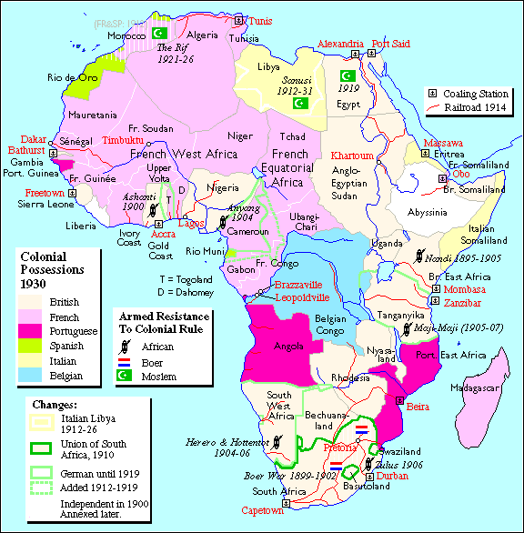
Because European countries divided Africa up as they wished, they did not consider the African people or their physical regions. The primary goal in creating Africa’s political boundaries was to acquire as much territory as possible so that more African resources could be utilized in as efficient a manner as possible. The result was a continent with some very illogical boundaries.
Some boundaries divided tribes. Some countries combined people who were cultural enemies or total strangers. Some countries are very small, while others are very large. Many are landlocked which hurts their ability to trade. Some countries have almost no economic base on which support a country.
Important Factors to Consider While Redrawing Africa:
Access to Open Waters: Landlocked countries have difficulty with trade because shipping is the cheapest way to move bulky commodities. Trade affects the economy, which affects the wealth of the government, which affects the amount and quality of the services it provides the people. All of this can affect nationalism within a country.
Land Area and Population: A country needs enough land and people to be economically competitive in the world. If a country has a lot of land, it has a better chance of having a variety of climates, landforms, and minerals. This will improve its chances of having a mixed economy. Which means having a variety of ways to make money. If a country depends on a single economic source, its chances of failure increase greatly. Self-defense is also a factor. If borders are too large, this can become a problem.
New Names for Countries: You must give new countries a name. New names should reflect something about a country’s history, geography, cultures, or natural resources. Do not just give the new country a silly name or some combination of student names from your group! Be thoughtful, do some investigating about the areas involved.
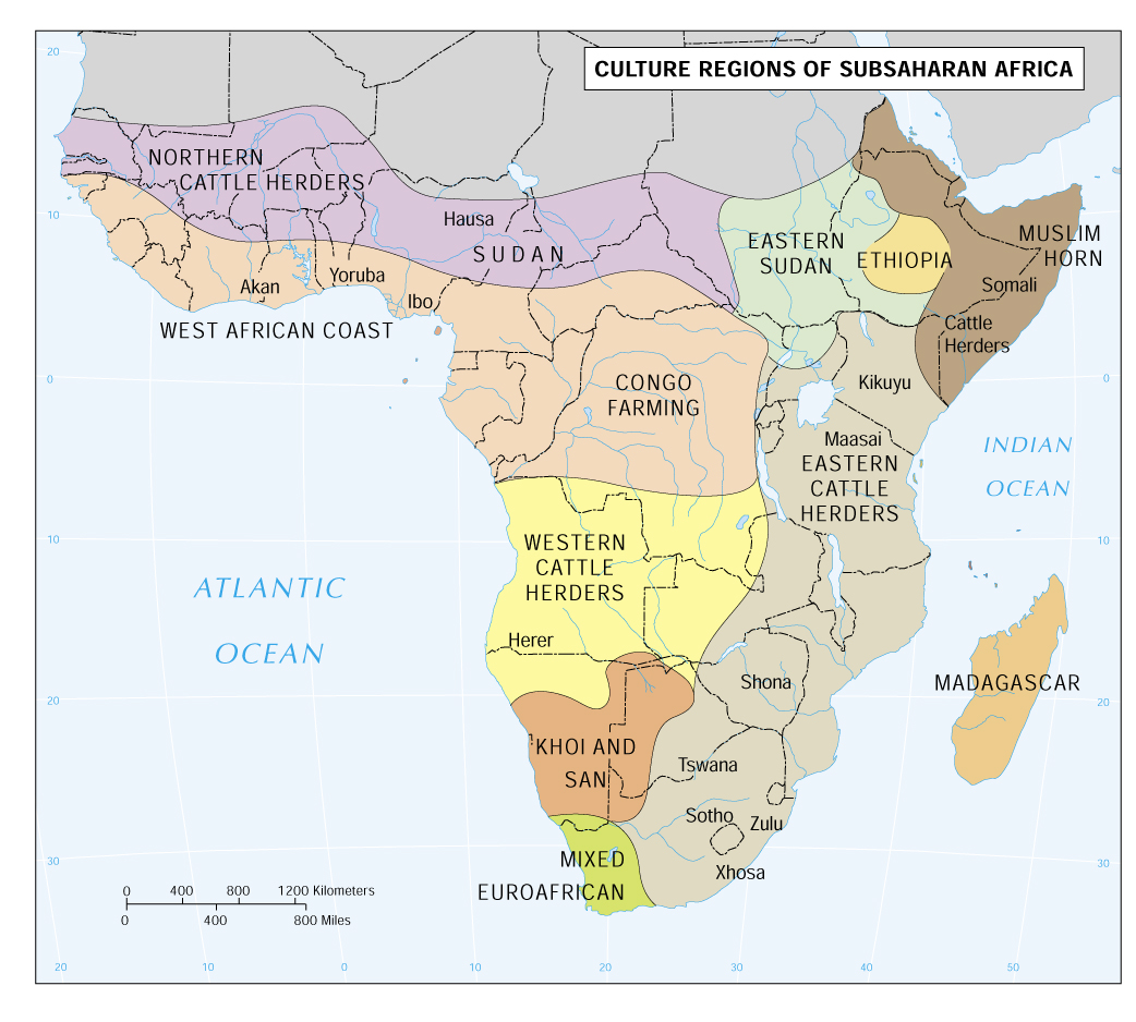
Culture: One of the key difficulties in Africa today is that the borders were placed with little regard to the location of tribes, kingdoms, or ethnic groups. It will be very difficult to solve this problem because there are so many tribes in Africa. Sometimes European boundaries have split tribal groups by creating national boundaries that divided them. Sometimes tribes that did not get along or barely knew each other were put together in the same country. If they at least had something in common like language, religion, race or occupations, they would have a better chance of getting along!
Mineral Wealth: Every country would like to have mineral wealth. However, minerals are frequently clumped in certain areas, while other regions have none or almost none. The uneven distribution of minerals in Africa makes it very difficult to create countries with reasonably equal amounts of minerals. You should expect some countries to be considerably wealthier than others, no matter how you try to avoid it. If you do distribute minerals fairly evenly, you might create another problem, because other cultural or physical factors had to be slighted to do so.
The Islands: Do not forget to put all the islands around Africa into countries. The countries of Cape Verde, Equatorial Guinea, Comoros, Seychelles, Mauritius, Madagascar, and the territories of the Canary Islands (Spain), Reunion (France), and Zanzibar (part of Tanzania) need to be included in your new Africa map.
Kinds of Boundaries: Some Are Better Than
Others.
1. Boundaries that pass through large concentrations
of people are generally not good. Example; Rivers are often used, but for
convenience, not for good boundary making. Why? Lots of people usually live
along rivers. Water is a valuable resource that will cause disputes over its
use, how much is used, and how water quality is maintained.
2. Mountains and coastlines are usually excellent
boundaries because they already divide people from each other.
3. Lakes can be good or bad, depending upon the size
of the lake and the amount of available fresh water.
4. Latitude or longitude lines can be good or bad
depending upon how many large population centers they pass through.
5. Cultural borders such as those formed by racial
groups, religious groups, or language groups can make good boundaries because
they promote nationalism within countries.
Resources: Thematic Maps
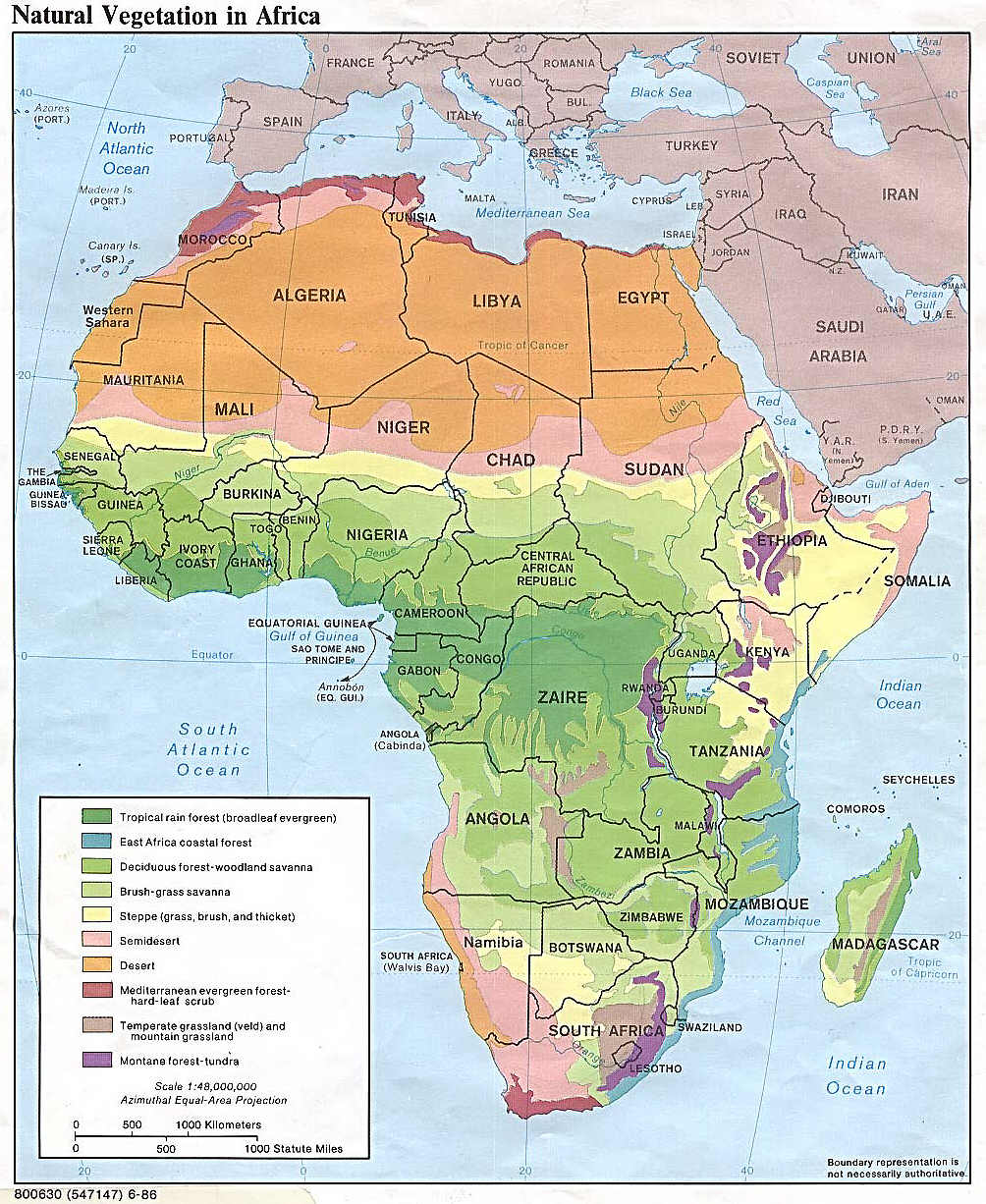
| What is the land like? |
Physical Map (Relief)
|
| What about the population? |
Population Density
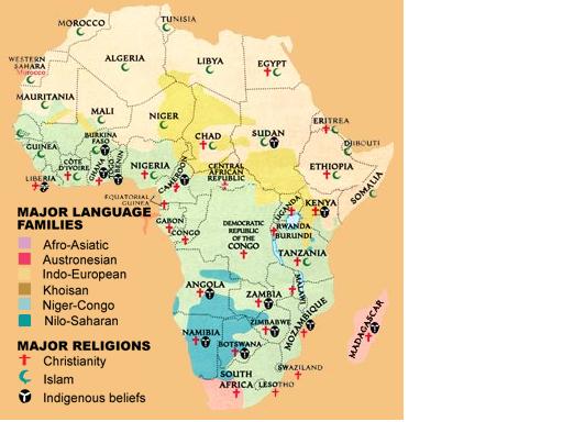
Islam in
Africa
Traditional Religions Over Time
|
| What types of natural resources are there in Africa? |
Minerals
|
| Where are the cultural-political boundaries located? |
Kingdoms & Empires African states (15th - 17th c.) African states (prior to 1870) Sub-Saharan African Culture Regions
|
| How was Africa divided up in the past? |
Historical Map of Africa - 1630 A.D.
Historical Map of Africa - 1885 A.D. Political Entities Before 1885
|
| How is Africa currently divided up? | Current Map of Africa - 2005 A.D. |